The Abandoned Village of Fociomboli

I have been organizing my photographs during this continuing lock-down situation and it’s both a rewarding and an emotional experience. There is so much happiness in the photos in the wonderful times I’ve had with friends and relatives. There is however, some sadness. It’s not just those persons we have lost through the grim reaper, it’s the friendships we have thrown away through misunderstanding and intolerance or just changes in attitudes. As the great Doctor Samuel Johnson wrote: ‘ life has no pleasure higher or nobler than that of friendship. It is painful to consider that this sublime enjoyment may be impaired or destroyed by innumerable causes, and that there is no human possession of which the duration is less certain’.

Certainly friendship is a transient phenomenon. Humanity, sadly, takes hardly any example from other animals whose solidarity and faithfulness is proverbial like the swan, the yellow crested penguin, the gray wolf or the French angelfish.

penguin

Looking through photos of by-gone parties and get-togethers it’s hard to believe that people we would not be in any hurry to see today were once our treasured guests! Ah… such is the sad fate of humanity….or dishumanity!

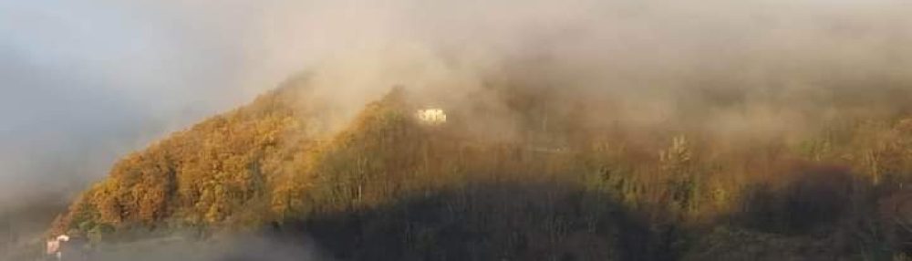
More pleasurable are those photographs dealing with places and, although now technology can tag these scenes with their precise location, there was a time when we had to rely on our memory. Such is the case with my photos of one of the many abandoned villages in our Serchio valley whose exact location I could not remember.

For there was once a time when families would abandon their winter dwellings and practise transhumance, moving flocks of sheep and goats to the Apuan mountains’ upper pastures. Summer villages would spring up, complete with their chapels, to take full advantage of the luscious summer meadows.

Immagine 018

I placed my photographs of one of these villages on the Apuan Mountains web page at https://www.facebook.com/groups/63530040096/ asking if anyone recognized the location.

I quickly obtained an amazing response with over a hundred reactions. I think I now know what the name of the place is!

There was, however, disagreement among some respondents about whether the village was Campanice or Col di Favilla. Let the comments speak for themselves:

The place is Col di Favilla. In 1921 it was still an inhabited village. There was a village shop, a tavern and a tobacconist. Until 1970 it was lived in by an elderly husband and wife. They were shepherds who raised Pontremolese cows. When these cows died the bull remained for a long time time in a wild state. This bull often attacked hikers and my father was a victim.The church was renovated with donations from emigrants to the Americas”.

Immagine 022

However, another person writes:

“It is not Col di Favilla. It was completely abandoned in the 1950s and the church was restored by emigrants living in the Versilia plain. The cows were left in the wild by a lady from Isola Santa called Vince. I think you’re confusing it with another place.”

Campanice seems a popular choice of location.

It’s Campanice. It’s under the Freddone mountain that divides Campanice from Puntato mountain. It’s reached from Fociomboli going from Merletti bridge immediately after the Cipollaio tunnel. Together with Favilla it’s another village not too distant from the Pizzo delle Saette in the Pania range. You can get there by going up the path that crosses Isola Santa dam or by going down from Mosceta or from Puntato. The roadway there is closed by a barrier because it’s private. However, your photos show Campanice. If I am not mistaken it would have its annual feast’s day.”

Campanice is again confirmed as the village’s name:

“It’s Campanice, with behind it the west ridge of Mount Freddone.” An explanation of the name follows:The name ‘Campanice’ means ‘field sown in panic’… the village was born as a mountain pasture in Terrinca along an ancient transhumance road.”

Finally another commentator suggests the following visit:Go back and then take a walk to Puntato behind the Freddone….another paradise.”

Anyway, thanks to all those contributors who answered my question asking for a location for my photographs. They really make me want to return to the enchanted abandonnment of a village which I visited with a friend those many years ago, a friend who, alas, is no more – not because of any misunderstanding but because of the grim reaper himself.

Immagine 011


Cannibalism at La Chiesaccia

Fornovolasco is an attractive little town at the head of the Turrite di Gallicano valley. It has an iron-smelting past having been founded by master smiths from Brescia. The name, in fact, means ‘Volasco’s furnace’, Volasco being a common surname in that north Italian city.

There are several wonderful walks with a starting point from Fornovolasco and, on one occasion for us, with a finishing point when we descended from the summit of that queen of all Apuan peaks the Pania Della Croce.

We were lucky not to be eaten alive according to a story we were later told. It’s to do with the cannibal friars of Fornovolasco.

Going up the Turrite di Gallicano stream through the Fornovolasco woods on the path that leads to Monte Forato one comes across a ruin known as the ‘chiesaccia’.

Immagine 008

Italian has various suffixes that can be added to a noun. For example, if ‘piatto’ means ‘dish’ adding ‘ino’ to the end of the noun, changing it into ‘piattino’, means ‘little dish’. Similarly, ‘one’ added to ‘piatto’, changing it into ‘piattone’, means a big dish. Adding ‘accio’ and changing ‘piatto’ into ‘piattaccio’ means a bad dish (in the case of food) or an ugly dish (in the case of crockery).

So ‘chiesaccia’ may mean an ugly church (in terms of its architecture or structural condition) or a bad church in terms of its clerics and beliefs. I leave you to decide what meaning should be applied in our case.

In 1260, the ‘Libelli extimi Lucanae Diocesis’, a document listing all churches, monasteries and places of worship in the Lucchesia, names the ‘chiesaccia’ among those churches dependent on the Pieve di Santa Felicita of Valdicastello. The latter structure, consecrated to S. Maria Maddalena, was located in Petrosciana along a branch of the Via Francigena, at the time the only route between the Middle Serchio valley and the Versilia. The Augustinian friars were its custodians from around 800 AD.

The “Chiesaccia” was mainly used to welcome and refresh wayfarers who, for business or pilgrimage, travelled from the Garfagnana to Versilia and the sea via the Foce di Petrosciana pass. It’s said, however, that these friars were not as pious and merciful as they wished others to believe. In fact, wayfarers who stopped for hospitality at this monastery were never seen again! The reason? During the night the friars gave themselves to cannibalism and ate the poor wayfarers alive, maybe with a little salt and pepper added. During these “special” evening banquets the bells of the monastery would ring throughout the valley.

Hearing the nocturnal sound of these deadly bells, the local faithful knew that the friars had feasted that night too!

Immagine 009

Another version connects the derogatory “Chiesaccia” to the fact that the monks, if not actually killing them, would frighten and prey on the wayfarers and pilgrims who passed along the Petrosciana path. What can one say? Legends are not born by chance!

The indications for the C(lub)A(lpino)I(taliano) signed paths are soon spotted at the bridge next to Fornovolasco’s ‘La Buca’ inn. After about ten minutes the paths leave the asphalt road. They continue together passing first a spring and then a cave known as ‘la tana che urla’ (the den that screams) because of its remarkable echo. Shortly afterwards the paths divide: no. 6 leads to Petrosciana while no. 12 heads for the amazing natural arch of Monte Forato (see my post on that at https://longoio.wordpress.com/2013/06/11/crossing-the-monte-forato/).

Follow no 6 that with a long but fairly gentle ascent alongside almost all of its stretch up a stream.

Immagine 001

Along this path you will find the ruins of an old mill

Immagine 006

and then come across the “Chiesaccia”.

Immagine 007

If you manage to avoid being barbecued by the monks you can continue up and reached the Petrosciana pass and the path following on which is number 137.

Immagine 014

Happy walking!

Pretty Pinner

Pinner was just a name until the other week when I caught a glimpse of its high street from the H13 bus I was on travelling from Ruislip lido (see my post at https://longoio3.com/2020/06/15/londons-best-beach/). I was amazed at how a Greater London suburb could produce something so much like a rural village scene with its half-timbered buildings and church tower at the top of the hilly street.

20200611_142355_HDR

We returned to Pinner for the mundane but exceedingly necessary task of collecting a toaster from its Argos store nestled within a Sainsbury conveniently close to the station on the Metropolitan line so eloquently hymned by the heritage writer John Betjeman.

Pinner dates back to the tenth century when it was first recorded as a hamlet called Pinnora after the river Pinn which runs through the town and which can be glimpsed in a handerchief of a garden on the main road.

pinn bridge-lg-sep-16

The parish church of St John the Baptist dates back to the fourteenth century and there are domestic dwellings surviving from the sixteenth century.

However, it was with the coming of the Metropolitan railway that Pinner expanded rapidly, especially during the inter-war period when a number of significant art-deco flats and houses were built. Here’s one I spotted, the grade II listed Elm Court with its graceful entrance arch.

elm

Pinner is a traditional home of retired colonels and stockbrokers and it’s clearly an affluent part of London with leafy avenues and large houses but I didn’t find it particularly snooty or pretentious unlike other ‘affluent ‘areas such as Hampstead or Belgravia.

Strangely Pinner has no Waitrose, an iconic sign of gentility if there ever was one, but surprisingly it possesses a very well stocked Lidl discount store at the top of its high street instead.

We came across a fine fish and chip shop and, with one of the largest cods we’ve seen in a long time, headed to the delightful Pinner memorial park nearby.

20200616_122309

Formerly the garden of a large house known as West House, once owned by Horatia, the daughter of Horatio Nelson and Lady Hamilton, the park is small but perfectly formed.

20200616_111318

It has a fine collection of tall pines and other more exotic trees harking back to the park’s history,

a sweet duck pond,

a cafe (now open for take-aways) and a museum dedicated to Pinner’s best known past inhabitant Heath Robinson, the cartoonist who drew those wonderfully devised machines with such complex pulleys and wheels to perform the simplest of tasks like the one for an easier way of conveying green peas to the mouth,

peas

the tabby silencer, which automatically throws water at serenading cats

and the one for testing artificial teeth.

testing-artificial-teeth

Unfortunately the museum, which also hosts contemporary art exhibitions still remained closed at the time of our visit – a good reason to return.

The Memorial garden are so called because they also contain within West House a memorial to all those killed in the two wars.

With its annual street market, one of the few places left in the UK that still holds one, the lowest crime record in all London, its good schools, its Carluccio Italian restaurant, its balanced ethnic mix, its wide variety of individual shops, its high life-expectancy rate and its healthy climate Pinner is clearly an attractive place to investigate.

Next time I think I’ll explore some of the town’s art deco treasures and also take in the expansive Pinner country park…and, of course, have another delicious fish ‘n chips from the five-star rated ‘Ideal Fish Bar’.

20200611_143149


Cassiobury Park

I reached Cassiobury Park via the Metropolitan line’s Watford branch. The station there is rural in character and it’s just a short walk to the park’s entrance.

Like so many open spaces in and around London Cassiobury was linked to a fabulous mansion belonging to the Earls of Essex. Here is a print of the estate in the eighteenth century. It must have been truly magnificent.

Cassiobury_Park_by_Kip_and_Knyff

Unfortunately the house, like many others when the world changed radically after the Great War, proved too expensive to maintain and it was demolished in 1927 with many of its fixtures sold. When one thinks that the house was decorated by the likes of Grindling Gibbons and Antonio Verrio its loss is quite considerable, although large part of it were reconstructed in Bedford, New York USA and many of its treasures are spread in museums throughout the world.

Luckily the park survives and has not been a victim to the area’s endemic house building. Comprising over 190 acres it still preserves the monumental avenue which lead to the vanished mansion.

20200612_115330

There’s a lovely spread of woodland, lawns and waterways: both the river Gade and the Grand Union canal wind their way through the park.

The western part of the park consists of Whippendell wood, a tract of ancient forest consisting mainly of oak, ash, beech and silver birch trees. Here one leaves the civilised part of Cassiobury behind and enters into a wild wood like that described in ‘The Wind in the Willows’.

20200611_131834

The wood gives way westwards to large fields of corn bounded by dense forests.

20200612_134046_HDR

I could have carried walking until goodness knows when but decided to reach urbanity by cutting across a narrow path leading to a delightful hamlet called Little Green.

Here I met a horse who was tossing an empty container up and down – clearly he was getting irritated by the fact that none of his human servants had refilled it with his oats!

20200612_134403

Passing the remains of a little pond

20200612_135129_HDR

I eventually reached a housing estate at the end of which a bus returned me to Watford, this time to its ‘junction’ station and homewards.

London’s Best Beach

One of the advantages of the current lock-down is the time we have to explore our local area. There are sights and beautiful corners we never believed existed until now. Does it really have to take a pandemic to discover them?

I’ve already written posts about discovering parks and open spaces like Fryent (https://longoio3.com/2020/05/06/the-countryside-in-the-city/), Welsh Harp (https://longoio3.com/2019/10/23/i-laghi-di-londra/) and the Duke of Chandos’ estate (https://longoio3.com/2019/07/15/il-duca-piu-ricco-dinghilterra/).

My curiosity was aroused by reports of a lake at Ruislip. Last week I set out to explore its woods and its lido. Though not exactly the Venice lido, Ruislip’s has its own very special charm and is encircled by gorgeous woodland through which a miniature railway wends its sylvan way.

The lido was originally opened as a feeder reservoir for the Grand Union canal in 1811. (See my post on that at https://longoio3.com/2020/06/05/can-do-canal-walk/ ). However, it did not achieve this job satisfactorily and the role was stopped in 1851.

In 1933, during the thirties craze for open-air activities the lake was inaugurated as a lido complete with boating and swimming facilities. It’s truly the nearest London may get to emulating the Costa Del Sol with its sweet sandy beach complete with pirate ship!

The enchanting walk round the lake through the ancient woods has a number of small jetties where one can observe and feed the wetland denizens of the lake.

It also includes a fascinating ‘planets’ trail marking in scale the distances between the planets of our solar system. Thus, there’s a long walk between Neptune and Uranus but towards the end Mars, Earth, Venus and Mercury are just a few feet from each other!

In happier times I hope to return and take a ride on the UK’s longest stretch of one foot gauge miniature railway and perhaps even take a dip in the lake waters. May both facilities reopen soon…together with the cafe and bar.

A Concert in the Sky

One of the greatest losses, not only for the Lucchesia but for the whole musical world, as a result of the horrible pandemic, which is showing no end and no mercy, is the death in March of Maestro Luigi Roni. Born in the Serchio Valley’s village of Vergemoli in 1942, Roni first studied the bassoon in Lucca before changing to singing. He made his debut aged 22 at the Spoleto festival playing the part of Mephistopheles in Gounod’s opera ‘Faust’.

Roni sang with such greats as Montserrat Caballé, Luciano Pavarotti, Plàcido Domingo and José Carreras at La Scala, Vienna State Opera, Paris Opera and New York’s Metropolitan. One of the bass singer’s last performances was in April, 2019 when he sang the part of Simone in Puccini’s ‘Gianni Schicchi’ at Genoa’s Carlo Felice theatre.

Equally sad is the fact that Roni’s wife died shortly before him – another victim of the deadly virus. But, having left each other for a short while they are together again. Love can be that strong sometimes.

Roni retained a special affection for the valley in which he was born and in 2002 founded the ‘Serchio delle Muse’ festival with the aim of bringing great musical performances to the remotest villages of his beloved ‘Valle del Serchio’.

We have always looked forwards with eagerness to this remarkable summer festival. The venues chosen for it are often remote and unknown to most people but not less beautiful for that. Town piazzas, forgotten churches and ancient palaces have all featured in the festival’s performances. One particular venue, however, literally tops it all for me. This is the concert regularly given at the Rifugio Rossi by the slopes of that mother of Apuan mountains, the Pania Della Croce.

To get to the venue is a couple of hour’s walk up footpath no 17 which leads to the extensive alpine-like meadows below the rocky Pania. The way is quite magical. The first part of it snakes through dense woodland before thinning into a birch forest and then freeing itself in the glorious uplands of the Pania massif.

DSCN3713

The singers and the instrumentalists all have to take the same path and clearly must be reasonably fit to tackle the rocky way. There is no helicopter service laid on except, perhaps, for the piano (though not for the pianist!).

Arriving at paradisiacal heights we spread ourselves out above the rifugio and waited for the performers to assemble.

In 2007 it was a soprano recital accompanied by a band of brass and introduced by the inimitable Debora Pioli.

Before us extended the vastest of landscapes. To the right rose the path which led to the summit of that most majestic of Apuan mountains, the Pania della Croce and to the right the lower, but no less magnificent summit of the Pania Secca (dry Pania not only because of its extremely rocky contours but because water in limestone country tends to hide itself undergound.) At our feet the valley of the Turrite found a way through the crags and the air was of the most wonderful purity.

Among the audience Maestro Luigi Roni can be recognized with his lordly grey beard and his considerable presence. It seems so unreal that he is no longer with us. Although aged sixty-five at the time of my photo Roni was as sprightly as ever and in excellent health. He had to be to get up to our heights!

The concert in such a heavenly setting was glorious. The young soprano had more than enough breath in her after climbing to the natural amphitheatre we lay in to make a fine show of the medley of operatic arias and traditional songs and her dulcet tones stood out brilliantly against the excellent accompaniment of the brass ensemble.

As the music faded out towards its close so the sunset enfolded the audience in its golden colours  and the mystery of an Apuan night descended upon us.

Everything must pass. This is life’s tough lesson which has to be re-learnt time and time again because we never quite believe it. For who knows where the time goes? That is the eternally unanswered question. All I know is that we have been privileged to be member of the audience at the concerts Maestro Roni has organised as part of his ‘Serchio delle Muse’ summer festival. Majestic cathedrals and the remotest of mountain chapels, town squares and village greens have all echoed to some of the most inspiring music thanks to his  efforts.

Together with his friends and admirers I take my hat off to this great man of our valley of the Serchio. Departed from this earthly life he lives on in our memory of the most exquisite music. We must be ever thankful that that we are fortunate enough to have enjoyed the generous patronage of true gentlemen like Maestro Luigi Roni.

Can-do Canal Walk

Some days ago we explored the stretch of the Grand Union Canal, which passes near us in Brent, leading into central London. We found the towpath very much in use with several cyclists, most of whom were courteous enough to warn us of their approach else one of us might easily have finished in the greenish canal waters!

I wanted to find the spot where the waters of the Brent River feed into the canal but was unable to locate it precisely. I wonder how the canal gets its refill from the river.

Of particular interest is the canal’s bridge over the North Circular Road with its stretch of ‘dual carriageway’. The divider between the two branches has a shield displaying the arms of the vanished county of Middlesex which has been absorbed by Greater London.

I always find it extraordinary when a canal crosses a road.

The North Circular was itself quite busy although not yet reduced to gridlock as it often is under ‘normal’ conditions. Traffic is, nevertheless, increasing with a loosening of lockdown regulations and doubtless the cleaner London air we breathe now may again recede in quality.

20200517_170647_HDR

The canal was clearly less busy than the road but there was time to spot a longboat resembling a Viking ship, this time transporting not horn-helmeted warriors but a Hindu religious group singing to the accompaniment of drums. What a relaxing way to spend an afternoon!

20200517_171435_HDR

It’s a real pity that this otherwise idyllic part of London’s backwaters is often badly littered largely by beer cans and spirit bottles. It seems that it’s difficult for some people to openly consume alcohol in their family homes, let alone take their litter home with them!

20200517_172951_HDR

Volunteers should be encouraged to collect the cans: after all a deal of money can be made out of this material not only for the metal contained in them as suggested by this firm:

https://www.brysonrecycling.org/recycling/cash-for-cans/

but also because some people actually collect them as seen at https://www.ebay.co.uk/b/Collectable-Beer-Cans/3919/bn_78214574

Some beer can labels are rather rare and can sell for over £10 even when empty!

Let’s hope that more beer can collectors will be conscripted.

20200517_172057


They Had Sailed from Erith

Apart from knowing Erith as a stop on the railway line to Dartford I have loved its mention in one of Joseph Conrad’s greatest works ‘Heart of Darkness’ where he writes:

“Nothing is easier … than to evoke the great spirit of the past upon the lower reaches of the Thames. The tidal current runs to and fro in its unceasing service, crowded with memories of men and ships it had borne to the rest of home or to the battles of the sea. It had known and served all the men of whom the nation is proud, from Sir Francis Drake to Sir John Franklin…the great knights-errant of the sea. It had borne all the ships whose names are like jewels flashing in the night of time, from the Golden Hind … to the Erebus. They had sailed from Deptford, from Greenwich, from Erith…they all had gone out on that stream. What greatness had not floated on the ebb of that river into the mystery of an unknown earth! The dreams of men, the seed of commonwealths, the germs of empires”.

Erith railway station is a pleasant nineteenth century Italianate building with characteristic dragon teeth eaves on its platform coverings. A path leads to the riverfront.


The Thames is a river with one of the most varied widths in its course through a capital city. At Teddington little more than a rural stream by the time the Thames has reached Westminster it inspired William Wordsworth to declare:

“Earth has not anything to show more fair:
Dull would he be of soul who could pass by
A sight so touching in its majesty.”

Here is the Thames as it appears taken on my journey home on the South East railway line; the railway passes by Southwark cathedral before entering Cannon Street station.

I was stunned by the view of the Thames at Erith. Already doubled in width since crossing the City of London the iconic river fully displays its estuarial properties here, particularly at high tide. On a fine day with fresh gusts of wind blowing across a true blue sky and sea-birds flying overhead it is truly an exhilarating panorama.

20200522_142553

The riverfront has been considerably enhanced by the gardens through which the Thames river walk passes:

A little wooden pier tempted me to walk down close to the water’s edge. Not too far, however, as it became a little slippery!

I walked into the town passing a row of old cottages hidden behind scaffolding and the Erith Playhouse where many years previously I had attended a performance of Gilbert and Sullivan’s ‘Princess Ida’, one of his lesser known operettas but full of his finest music, where one of my work colleagues was performing as member of the choir of ‘girl graduates’.

Entering the town I passed the Carnegie library. Designed by William Egerton, and funded by the philanthropist Andrew Carnegie it opened in 1906. We knew it for the fine museum it housed but this time I found the distinguished Edwardian building boarded up and fenced off. I was alarmed. Later I was relieved to find out that the library has been moved to a new centre but that fortunately the ‘old’ library has secured National Lottery funding this year to restore the former library building to provide new community facilities.

20200522_141827

Sadly Erith town centre has been a victim of the worst sort of urban modernization of the 1960’s so there aren’t that many old buildings left in its disemboweled heart.

One of the few left, the White Hart pub, has a fine mural by Gary Drostle on its outside flank displaying a characteristic Thames sailing barge.

20200522_144057

The Thames sailing barge is a type of commercial sailing boat once common on the East Coast of Britain. With its shallow draught this type of vessel is well adapted to the Thames Estuary and, although no longer dedicated to commercial purposes, the remaining examples are used for races, regattas and wedding parties.

My walk finished at the C of E Christchurch, a fine late Victorian building by architect JP St Aubyn and dating from 1874. Together with the Carnegie library it is Grade II* listed.

20200522_152935_HDR

The exterior displays a fine broached spire separated from the nave by a short passage and a sculpture of the good shepherd on its doorway:

Unfortunately the interior was locked because of the current health crisis. However, here is a photo of it taken from on-line public sources.

The interior has been well summed upon by that doyen of architectural historians Pevsner who states: “Nave arcade has round piers, with stiff-leaf capitals. Nave has three tier hammer beam roof with curved braces supported on stone corbels. Chancel has five fine lancet windows by Hardman of 1875 depicting scenes from the Gospels, reredos of painted triptych of the Adoration of the Magi in a C15 Italian style by A O Hemming of 1904,

ery

stencilled decoration, triple sedilia and polychrome tiles. Nave has original carved wooden lectern, pews, stone and – granite font, wall tablet on west wall to Thomas Ruck, organist between 1881-1918 with mosaicwork cherubs and eight painted panels depicting scenes from the early history of the Church in England from the martyrdom of St Alban to the martyrdom of St Edmund by Ward and Hughes of 1906-9.”

Erith has the longest pier in London. It was once used for commercial purposes but is now the haunt of anglers:

Something about the town’s history: Erith has a past dating back to Neolithic times and traces of prehistoric settlements have been revealed by the London archaeological service. The Romans were there and the Anglo-Saxons built the original church of Saint John the Baptist which is another important Erithian church which I have to visit someday.

Henry’s famous warship, Henri Grâce à Dieu, was fitted out there in 1515 and is allulled to in the Conrad excerpt I have previously quoted.

Erith remained a small riverside port until the nineteenth century when it expanded with establishment of various industries. One of these was the British Insulated Callender’s Cables and Pirelli, for which my wife worked as interpreter.

There are a number of interesting modern works of art spread out in the town. Most lively is the ‘The De Luci’ ‘dancing fish’ mosaic statue, otherwise known as the ‘Erith Fish’, at the roundabout in the town centre designed and created by artist Gary Drostle in 2006. It was inspired by the former Erith Urban District Council’s coat of arms which featured three intertwined pikes. The pikes were, themselves, adapted from the family arms of Richard de Luci, a supporter of King Stephen, assistant in the murder of Thomas a Becket founder of Lesnes Abbey and owner of Erith during the reigns of King Stephen and King Henry II. (For more on this story read my post at https://longoio3.com/2019/08/09/un-perdono-londinese-per-lassassinio-di-thomas-a-becket/)

20200522_152310

I was pleasantly surprised by Erith. Clearly the day was fine and the place was more than quiet due to the lockdown but it was certainly less grim than I remember it to be. The ghastly brutal town centre of the sixties has been largely replaced by a more acceptable shopping centre, thanks also to the regeneration provided by the Thames Gateway project. Most of all, Erith gorgeously reveals the quasi-sacred Thames in all its glory.


show

Neighbouring towns, villages and places


The Ford on the River Darenth

Dartford, a town eighteen miles to the south east of central London, goes back a long way. Its importance arose because of the intersection of the river Darent with the main Roman road from London to Dover. Originally a market town and with some important industries Dartford has become a largely commuter centre for London. It’s also where the M25, London’s orbital motorway, crosses the Thames.

I visited Dartford last week on a very hot day (for UK standards, temperature was 28C) and wasn’t expecting too much from this town. I was, however, pleasantly surprised, even in these lockdown days. I had known Dartford from the time my wife had been conducting market research there and the only significant thing I can remember is entering a fine pub and buying a book from a charity shop. It was called ‘The Interrupter general’, the diary of an English language teacher in Italy, which inspired me to try work experience in that country– indeed, live more or less permanently there.

I travelled by train and at Dartford station there was this commemorative plaque on platform two. A promising start to my visit to the town, I thought.

20200520_135612_HDR

I soon found myself on an attractive riverside walk (nineteen miles in length and lereal ding to the Sevenoak hills) along the Darent River.

20200520_151508

Here the river is near  its outlet into the Thames and, contained between two cemented walls, is a far cry from the Darent I recollect in its idyllic pastoral setting flowing past the sweet village of Eynsford where there is a real ford I’ve traversed on my Honda Transalp motorbike.

Part of the riverside walk leads under an impressive (for the UK) vine. Unfortunately there was still no sign of any grapes on it:

20200520_140837

The riverside walk carries on to the high street which still retains something of its former glory as a market town and has a couple of half-timbered houses.

At one end of the high street is the parish church, of Holy Trinity, originally a 9th-century Saxon structure with later Norman additions and Victorian restorations all overladen with some excellently flint-knapped walls. Its site near the left bank of the Darent is quite picturesque. I was clearly unable to visit Holy Trinity’s interior so could not see the plaque commemorating Richard Trevithick, the pioneer in steam propulsion who lived and died in Dartford.

The High Street has an impressive mural depicting industries and activities that have formed present day Dartford. Some of the town’s key industries, including brewing, paper-making, flour milling and the manufacture of cement, have unfortunately declined in the twentieth century.

20200520_142514

The purity of the river Darent’s water,  filtered from its source in the chalk hills, has been very important for the paper-making industry. The name Darent  (often found written ‘Darenth’ in older maps) derives from the Celtic phrase ‘stream where oak-trees (dair) grow’. I thought of how a similar quality of the water from the Lima and Serchio rivers in the Bagni di Lucca region has given rise to its own important paper-making industries.

At the other end of the High Street is the Royal Victoria and Bull Hotel, a pub with an impressive galleried interior.  Some years ago this watering-hole served as the temporary headquarters of my wife’s market research company.

20200520_142715_HDR

Unfortunately, as with the church, the ‘Vic and Bull’ remained closed to the public. So both spiritual and secular solace were denied to me on this visit.

We once attended an excruciating production of ‘Jane Eyre’ at Dartford’s Orchard theatre. Hopefully it will be able to offer something superior when it reopens! There’s a ‘Mick Jagger’ cultural centre too. I wonder if the iconic star has since performed here as he did for Lucca’s summer festival in 2017.

I also remember a visit to the Dartford museum and library and seeing a fine exhibition commemorating our prehistoric Neanderthaloid ancestor Swanscombe man (actually it was a woman) whose 400,000 year old skull was uncovered in the nearby chalk pits.

There was also an urban farm we visited at Stone Lodge with a lovely collection of animals and ancient tithe barns. Unhappily this has since closed down.

stone

In the marshes to the north of Dartford were two large hospitals. One of them, the City of London mental hospital, housed the tragic composer and poet Ivor Gurney who was diagnosed as suffering from ‘delusional insanity’. Up to two-thirds of his musical output remains unpublished and unrecorded.

(Ivor Gurney 1890-1937)

In the mid-1970s, the future Princess of Wales did voluntary work at the hospital. The hospital buildings have since either been demolished or converted into luxury flats. Some of the buyers of these have resold as they complained about hearing strange screams and voices within the flats’ walls.

In the village of Gombereto, near Longoio, there is a family who originally lived in Dartford. When I asked the lady of the household why they moved there she replied ‘fancy bringing up kids in Dartford?’ Obviously she knew something about Dartford that I didn’t. However, I did have a very pleasant time in this Kentish town and all those I met were particularly courteous towards me.

Green-Robed Senators of the Forests

The sweet or Spanish chestnut tree (Castanea Sativa) was introduced into Europe from Sardis in Turkey. Sardis was one of the richest cities of the ancient world and is famed for having invented the concept of currency. We visited the ruins of the ancient city in 1991, a journey which inspired this sonnet.


SARDIS


Amid scorched stones, the sordid root sprang here

in heaps of monoliths and pediments,

and drowned a childlike earth in blooded fear,

emasculated priests and bare laments.


Where is your gold and silver now, great King?

That burnished stroke has crumbled into dust

the temple votaries no longer sing

and all your treasury is turned to rust.


White columns’ tempest-shaken marble staves

against a broken sky, a raven screech

across the ether of uncoded waves:

this is the city wrecked upon a beach.


And yet what brilliance shines upon these stones

above dusk graves, beyond the vanished bones.

Sometimes disparagingly called ‘the poor person’s flour’, like the potato in Ireland and oats in Scotland, the chestnut once supported half the population in the hill villages around Lucca. Indeed it has been a staple food in southern Europe, Turkey, and southwestern and eastern Asia for millennia, replacing cereal crops where these were unable to grow well in mountainous Mediterranean areas.

Nowhere is this more apparent than in the Serchio and Lima valleys. Although unfortunately vast forests of chestnut trees have been largely abandoned since the last war as people have moved to the urban centres in increasing numbers and have replaced chestnut for cereal flour there are still areas with the most wonderful specimens of this noble tree, some of which are hundreds of years old (the Italian word for this is ‘secolare’).

Going beyond Albereta by the Prato Fiorito near Bagni di Lucca and descending into the Scesta valley I came across these stupendous trees with girths exceeding several yards. Some of them had hollowed out trunks into which one could easily enter as you can see!

DSCN1075

I count the Apennine chestnut forest as one of the most beautiful sights to be found on Earth. There is much emphasis and effort now in saving Earth’s rare fauna. I believe that the same emphasis should be given to these stupendous examples of our planet’s flora which should be properly protected against both encroaching disease and the vandal’s axe; they are in all senses of the word irreplaceable.

To the early Christians, chestnuts symbolized chastity. The tree enters into the religious celebrations of several European countries. For example, in France, the marron glacé, a candied chestnut is served at Christmas and New Year’s time. In Tuscany ‘marroni canditi’ are traditionally eaten on Saint Simon’s Day which is the 4th of July.

There is a fine museum at Colognora which illustrates the social and economic history of the sweet chestnut tree which I’ve written about at:

https://longoio.wordpress.com/2013/10/11/old-chestnuts/

There’s also a post I’ve written regarding specialties made from chestnut flour and the local festivals associated with it at:

https://longoio3.com/2018/09/21/nuts-about-chestnuts/

There’s more about taking walks in chestnut forests in my post at

https://longoio2.wordpress.com/2016/04/20/a-walk-up-the-scesta-valley/